
One day I came across a photo from 1893 showing a group of retail/office buildings on Gratiot Avenue (north Port Huron), which was still dirt. I was very curious about where exactly this block used to be. Looking at early directories wasn’t very helpful at first, but thankfully, Pauli’s 1894 bird’s eye view map gave a clue.
The group of buildings on a portion of Gratiot Avenue on this map fairly matched the proportions of those shown in the photo. And then after betting that the photo matched the map in that area, a light switched on in my head. One of those buildings is still standing today, and it was posted at this site previously. Why only the one building was saved when all the buildings around (including to the east and west) were razed, is something I’d love to find out. Some day. One thing is all too clear, though; much of this area of Port Huron seems to have been demolished for nothing.
After the images seen below is information on what businesses and such were in these buildings in about 1898 (hopefully, time will be found to present more information in the future; if you care to share anything in the comments below, or by contacting PHAHPA otherwise, we’d greatly appreciate it–and give you credit, of course).

Gratiot Avenue buildings (no further location description given), from the Art Work of St. Clair County 1893, no page (WH Parish Pub Co). View is looking to the southwest.
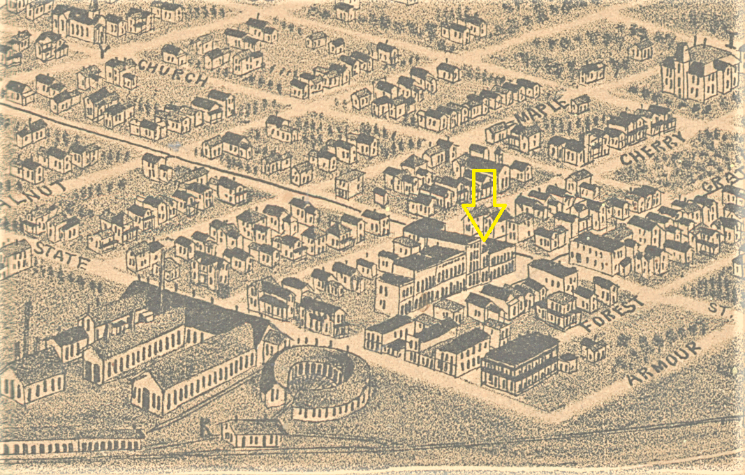
Portion of an 1894 map, showing the strip of buildings on Gratiot Avenue, between State and Elmwood streets, northern Port Huron. The yellow arrow indicates the one building still standing (C.J. Pauli, Port Huron, MI, Milwaukee: 1894). View to northwest.
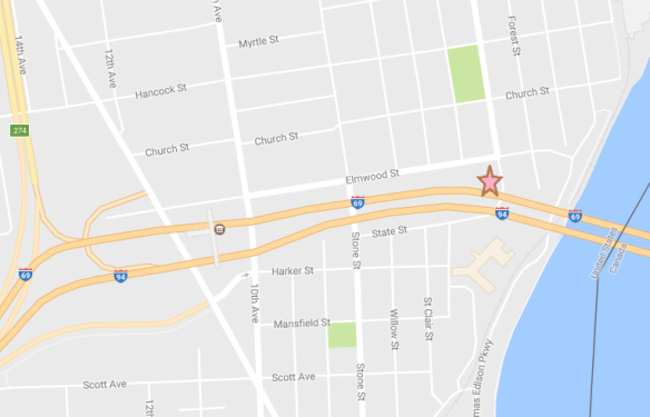
Google map of surrounding area today, with star indicating the former buildings location.

How empty it all is now. For what? (Google street view.) View to south-southwest.

2333 Gratiot Avenue, dated 1882. This building is amazing for having so much that is original still intact. Photo from March 2016. View to west.
According to the street listings and business directory of the 1899-1900 directory, the occupants of the buildings were:
2319 Vacant
2322/2323 GH French, clothing & shoes/dry goods (the photo shows that the French awning indicates RE French, and a Robert E French sold the same items in Fort Gratiot according to the 1891-1892 directory, page 218).
2325 Vacant
2327 Post Office
2329 Mrs. T. Irwin, Books and Stationery
2331 Vacant
2333 Bean & Brown, Grocers; Dr. JP Aiken; Archie B Miller
2335 HW Powell
2337 Cook & Hubbard
2339 RG Burwell, Druggist (part of this can be made out in the awning) and Dr. CG Brown
The photo shows a sign for Troy Steam Cleaners, with what looks to be “branch office,” at the north end wall. That end wall also has R.G. Burwell’s business name painted out in large letters. The three-story building has a name at top that I’m not quite sure about (P. Me – – son?).
On the other side of Gratiot there was a billiards hall, cigar seller (perhaps maker, too), bicycle seller, a hardware or furnace store, and an IOOF hall. On the opposite corner, at Elmwood and Gratiot, was the Grand Trunk Hotel. That building still stands, but has been altered. Gratiot Avenue between State and Elmwood seems to have been the happening place for that north Port Huron area. (Edit: I want to thank those who pointed out that these buildings are in the old Fort Gratiot Village area which had old buildings indeed, popping up north of the military Fort Gratiot [1814-1879]. The erection of this block of buildings may have caused the destruction of even older buildings that had come before. Fort Gratiot Village was merged into Port Huron in 1893.)
UPDATE
While we’ll write up a history of Fort Gratiot Township (which will of course include Fort Gratiot Village) some time soon, I wanted to post a couple of Sanborn Insurance Map images of the area here. Sanborn maps are simply very informative and fun, and I was surprised to find the 1887 Port Huron edition with Fort Gratiot Village in it; the front index did not show that this was included in the volume. Of importance is the fact that the names of the streets are different than they are today, and no doubt they were changed when the village became a part of Port Huron. And happy day, the tallest building–the one with a name on it that I couldn’t quite make out–is discovered to be the Edison Building. The initials in front match the person listed in the 1877-78 directory for this block: Peregan M Edison (he had a general store in the building) (page 174 of the Directory of the City of Port Huron, which includes Fort Gratiot, R. L. Polk & Co, Pub.s). But that’s not all. Further below is the same area from the 1898 Sanborn map, showing the street name changes and the infilling of more buildings in this area. It is amazing how many structures were removed for the making of the Blue Water Bridge.

A portion of page 12, 1887 Sanborn Fire Insurance Map (Library of Congress).

Gratiot, formerly Huron, at Elmwood, formerly Pine. Portion of 1898 Sanborn Fire Insurance map, page 17, Library of Congress.

Nice job!
LikeLiked by 1 person
Thank you so much!
LikeLike
Always enjoy your work Vicki.
LikeLiked by 1 person
Ohhh, thanks!
LikeLike
Pretty much the only original part of that building is the exterior shell. The interior was gutted and rebuilt several years ago. Was a restaurant for a while after that and now a defunct wedding chapel and upstairs apartment.
LikeLike
Thanks so much for commenting, Frank. There’s something wrong between my two accounts on FB, apparently, since I can’t comment on my own post at the Photos page (even when signed in at the group under my personal account). Just saying this in case you want to say more here. As it is, I’m copying some people’s comments as notes for future reference. Thanks again!
LikeLike
I just stumbled across your blog. Very interesting. I drove by the 1882 building this morning. It’s for sale. 😦 Hoping it doesn’t fall into the wrong hands. It is very sad how much history has been destroyed instead of valued and preserved.
Keep up the good work.
LikeLike
Thank you so much, Ash! I knew the building was for sale, but thought someone bought it by now. What I need to do is contact more people to find out what is really up with it – there is so much open area there it seems like they’d put in a parking lot for the convention center. If they want to do that, they should still save the building. It’d probably be more likely used successfully if there was foot traffic around.
LikeLike
Amazing. Thank you for doing this. Sure looks different today.
LikeLike
Thank you Bill!!
LikeLike
I think the reason this building owned by the French family is still there is because R. E. French became Senator of Michigan in a landslide Republican victory in a Democratic area in November 1892. He turned the store over to his son. R E French was the first mayor of Fort Gratiot. This makes it a historical building and that is why it is still there. That is my guess.
LikeLike
Thank you very much for that info!
LikeLike